
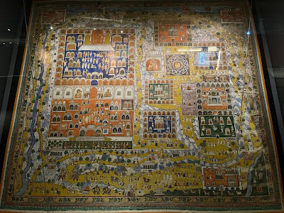
Asian cartography has a very special place in my heart. Cartography is Western-centric but the maps currently on exhibition until May 2022 at the National Library of Singapore’s Mapping the World: Perspectives from Asian Cartography, will show that in fact Asian cartography has a long lineage, predating Western cartography. These maps are worth several trips: not only are some of them quite rare (and difficult to access since they form parts of collections elsewhere), they span multiple kingdoms and dynasties, geographies and eras, from the religious Korean map Cheonhado (Map of All Under Heaven), Joseon Dynasty, 19th century, on loan from MacLean Collection, Illinois (Image 1) to the Idrisi world map of 1154 (on loan from the Bibliotheque national de France), produced by Arab geographer Muhammad al-Idrisi (1100-1165) and composed in accordance with the Islamic tradition of orienting the south at the top. (Image 2)
 |
| Image 1 |
 |
| Image 2 |
Maps of course are political instruments and ideological tools used to justify colonialism (and not just Western but also Eastern imperialism), and there are a number of these in the exhibition: such as Map of Khsach-Kandal showing the French colonisation of Vietnam, produced by Cambodian elites at the behest of French colonial authorities, as well as the stunning Daqing Wannian Yitong Dili Quantu (Complete Geographical Map of the Everlasting Unified Qing Empire), presented by Chinese cartographer Huang Qianren to Emperor Qianlong in 1767 to justify Qing expansionist policies.(Image 3)
 |
| Image 3 |
Particularly rewarding are the religious and cosmogonic maps on exhibit, such as the cloth painting of the pilgrimage centre of Shatrunjaya (Rajasthan, Western India, c. 1880) (Image 4) and the Nansenbushu Bankoku Shoka No Zu (Map of all the countries of the Jambu-Dvipa) compiled by scholar priest Hotan (1654-1738) who sought to depict the mythical mountain of Jambu-Dvipa comprised of lands recorded in classical Buddhist scripture. Influenced by Jesuit cartographer Matteo Ricci, the map also incorporated Europe, Africa and the Americas, making it a blend of the surrealist-religious with the real.
 |
| Image 4 Maps showing the exploration and voyages on land and sea, including that undertaken by Admiral Zheng He (1371-1433/35) and Emperor Qianlong’s third eastern imperial tour in 1778, inform not only about geographic expansion of knowledge, political aspirations, tribute vectors and trade routes, but they also tell stories about religious pilgrimages and cultural traditions, such as Emperor Qianlong’s visit to imperial graves in Mukden as ancestral legitimisation of his rule. Literary Mapping Given that this exhibition is taking place at the National Library (which to me is in one aspect synonymous with being a literary temple), I wondered how and to what extent Singlit authors have taken to mapping in their fiction. In response to a social media call, the five featured Singlit authors below provide a small but exemplary sample of the use of maps in Singlit, showcasing a rich imagination, diverse uses and across genres.
|
Jason Erik Lundberg’s A Fickle and Restless Weapon (Epigram, 2020):
In Jason Erik Lundberg’s wonderfully inventive fantasy novel, a mysterious cloud formation and a local resistance group embattle an imaginary Singapore named Tinhau. Asked about the creation of the map Tinhau (Image 5) in his book, Jason says:
“One of the cool things about all the worldbuilding that goes into creating a fictional country is coming up with a map to go along with it. I love maps in books, regardless of whether the subject matter is fantastical, because there’s something about seeing the layout of a setting that makes it all the more real in the mind, like a historical artefact. Way back in 2004 when I first started working on my novel, A Fickle and Restless Weapon, I hand-drew a map of my fictional island-nation Tinhau, with everything I’d need to keep me grounded in the geography, including district names, landmarks and various public transport train lines. It became invaluable when I actually started writing the book, because I could "see" where in the country my characters were at any given time, which helped so much with pacing and transitions. I also relied on the map when writing Diary of One Who Disappeared, a novella that takes place 25 years after Fickle. Epigram Books designer Jael Ng did a phenomenal job adapting my drawing into its finished form."
 |
| Image 5. Illustrated by Jael Ng. |

Kamaladevi Aravindan’s Sembawang (translated by Anitha Devi Pillai, Marshall Cavendish, 2020):
Set in the 1960s, Sembawang shines a unique light on five decades of social history concerning a tight-knit Indian migrant community who work at the Sembawang naval base, with a strong sense of how place plays a part in our stories. The photographs, historical notes, and the fictional stories written based on interviews with residents who had lived in the area blur the line between the fiction and the real in fascinating ways.
Anitha writes: “So many of our memories are tied to a place. The historical fiction novel, Sembawang, referred to many of the places that once existed in Singapore. A map of the Sembawang in the 1960s and 1970s was drawn up to help the reader visualize the setting of the book. This was done in consultation with old residents and old street directories. Only places that had a special place in the minds and hearts of the residents as well as in the story were included eventually in this map. Readers have found it incredibly helpful and former residents shared that the map took them down memory lane. Maps have the magic of triggering feelings of nostalgia.”
 |
| Image 6. Anitha's Handdrawn Map of Sembawang, 1960. |

A.J. Low’s Sherlock Sam and the Fiendish Mastermind in Jurong (Epigram, 2015):
Young readers in Singapore are understandably enamoured with the awesome Sherlock Sam series written by dynamic author duo A.J. Low. In their Popular Readers’ Choice Awards shortlisted adventure story set in Jurong, science and mapping come together in unexpected ways.
Felicia writes:
"The mystery in Sherlock Sam and the Fiendish Mastermind in Jurong, was inspired by an off-site Science Centre exhibition that replicated the Solar System using 10 sundial sculptures that were installed in various locations around Singapore. The coolest thing about the exhibition was that the distances between the sculptures represented the relative distances between the actual Sun and planets. The Sherlock Sam series is about geekiness, curiosity, science, and adventure, so we had the kids run around the island solving clues that would lead them from one sculpture to the next. The book wouldn't have worked without this map of the solar system!"

 |
| Image 7. Illustrated by Andrew Tan. |

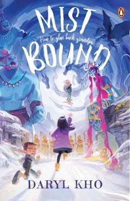
Daryl Kho’s Mist-Bound: How to Glue Back Grandpa (PRHSEA, 2021):
Daryl’s fun and fresh plot in his young adult novel Mist-Bound not only has an underpinning social exploration of vascular dementia, it also blends in local mythology in a quest similar to Jason and the Argonauts that includes plucking the nose hair of a baku and collecting sweat from a duyung. How does Daryl feature a map in his book?
He says, “This map (Image 8) shows the portion of Mist (my made-up land of myth, magic & monsters) and its key landmarks that the protagonist Alexis has to journey through, in her quest to gather the ingredients needed to brew Memory Glue. That’s the only cure that can put her beloved Grandpa’s broken memories back together again.”
 |
| Image 8. Illustrated by SillyJellie (@elliethopia on IG and Twitter, SillyJellie on FB) |
 |
| Map of Osho, Courtesy of Jocelyn Suarez |
